
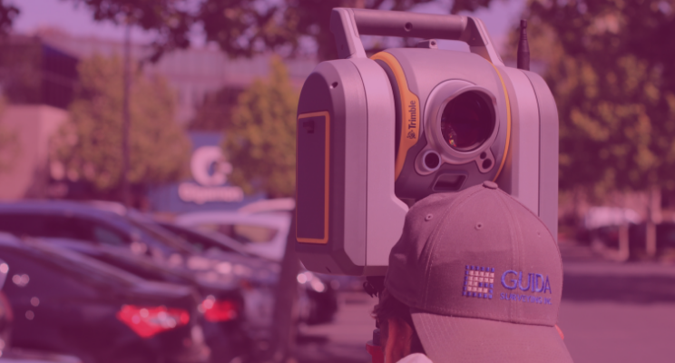
Although there are a number of ways surveyors can collect the data needed to create a point cloud, laser scanners remain the most popular and precise instrument. The pairing of aerial drones with laser scanner technology is increasing. Here, however, we will focus on terrestrial laser scanners, giving you a quick rundown of the options in the market and what to expect from different manufacturers.
Faro: A flexible scanning solution
Faro offers a range of popular and widely used laser scanners, some of which are generalists, while others are focused on specific use cases. Faro offers its own processing software (Scene), but its scanners pair easily with third-party options. This versatility, and the relative affordability of their hardware is one reason for the popularity of the company. Combined with the small size, fast scan speeds, ease of use, and often multi-purpose capabilities of their scanners, Faro has been a long time staple of the surveying community.
Founded in 1981, Faro has an annual revenue of over $360 million and is considered an industry leader in 3D measurements, imaging and realisation technology. Faro technology is popular with manufacturers as well as surveyors. Many of their scanners are focused on delivering precise models of objects, rather than surveying.
The Faro Focus series is their main product line for indoor and outdoor surveying. The Focus S 350 is the flagship scanner, specifically designed to overcome the challenges of outdoor scanning. It comes with an integrated GPS receiver, is lightweight and maximised for range. Capable of +/-1mm measurements at 25m, the FocusS 350 can deliver accurate measurements between 0.6m to 350m. The scanner comes pre-calibrated to accommodate dust, rain or direct sunlight and has internal compression technology to maximise the number of scans you can collect.
The Focus S 150 is a pared down version of the 350, lacking the GPS receiver and with a range limited to 150m. It is more suited to indoor spaces where neither of these factors will have a practical impact. The same goes for the Focus S 70, but with a further diminished maximum range of 70m. The Focus M 70 is the budget model, also delivering a maximum range of 70m, but with an accuracy calibration only capable of +/-3mm at 25m.
Leica: Scanning, processing and 3D modelling in one place
Leica Geosystems is a ‘premium player’ in the surveying industry. They create high-quality products with a number of diversified specialisations, and focus on delivering an end-to-end user experience. Rather than depending on third-party integrations, Leica encourages users of their scanners to rely on their in-house processing software. In fact, with the exception of a few limited partnerships, Leica scanners are only compatible with Leica processing software.
Leica’s main processing solution is ‘Cyclone’. Cyclone can be used with third-party scanners, and exports point clouds that can be paired with different 3D modelling software. Cyclone also offers 3D modelling capabilities. Cyclone, like Leica scanners, is high-quality, accurate and robust.
Leica products can be expensive, but users are buying into a complete ecosystem, and are guaranteed high-quality hardware and intuitive software. You can think of Leica as the Apple of laser scanners, restricting your total number of choices, but restricting them to only quality options. Their scanners excel at scan speeds, angular accuracy and limited range noise.
The staple Leica laser scanners are the Leica ScanStation P50/P40/P30. The P50 is the long-range model, capable of making high-quality measurements at distances up to 1 kilometre. ‘Range noise’ is limited to 0.4mm rms at 10m and 0.5mm rms at 50m. Range accuracy is 1.2mm + 10 ppm over the full range. It has a scan rate of 1 million points per second and delivers industry-leading angular accuracy paired with survey-grade dual-axis compensation.
The P40 and P30 scanners are optimised for closer range. The P40 caps out at 270m, and the P30 is effectively limited to 120m. However, for indoor scans, this limitation does not matter, and they both bring the same range noise metrics and angular accuracy as the P50.
All three scanners deliver colour information, making each a great choice where a highly realistic 3D colour model is the end goal.
Leica also offers the BLK360 and RTC360. The BLK360 claims to be the smallest imaging laser scanner in the world. It is compact and easy to use, however, it is limited in range to 60m and has an accuracy rate of 6mm at 10m.
The RTC360 is a premium, multi-purpose product. Easy to use and fast, the RTC360 is a great choice for mid-range scanning. Uniquely, it comes with a video-enhanced inertial measuring system (visual SLAM) that tracks the relative movement of scan positions in real-time. Together with more traditional GNSS receivers and an altimeter, these features improve workflows and ease registration. The RTC360 can make measurements up to 130m at speeds of 2 million points per second. It has an accuracy rate of 1.9mm at 10m and 5.3mm at 40m.

Riegl: Long-range point cloud laser scanners
For long-range scanners, Riegl is really second to none. They dominate the aerial market and are used heavily in the mining sector. But their products are expensive. Whether or not range is a priority is one of the main decisions you should make if thinking about investing in top quality Riegl hardware.
The Riegl terrestrial laser scanner mainstays are the VZ-Series. The VZ-6000 and VZ-4000 are their ‘standard’ products. They are both, however, capable of scan distances far in excess of other scanners on the market — 6km and 4km respectively. Even by Riegl standards, these are long-range specialist scanners. They deliver a respectable scan rate of 222k points per second, have built-in digital cameras, integrated GPS receivers and multi-target capabilities. At 150m, both deliver an accuracy rate within 15mm.
The Riegl VZ-400i and Riegl VZ-2000i are the cutting-edge Riegl products. They have a smaller range, 800m and 2500m. But that is still greater than most high-end, long-range specialist products on the market. What these products deliver is a multi-purpose workflow.
Both come with “innovative processingarchitecture for data acquisitions and simultaneous georeference in real-time”. Further, these pair with Riegl’s own processing software to execute on-site registration in real-time. The system is highly flexible, capable of bringing on peripherals to augment your processes, and are fully compatible with the Riegl VMZ mobile laser mapping system. At 100m, both are capable of an accuracy rate of 5mm.
Trimble: An American giant in surveying
Trimble is the American leader when it comes to both point cloud processing software and hardware production. Founded in 1978, they have an annual revenue stream nearing $3 billion. Trimble develops laser rangefinders, UAVs, inertial navigation systems and GNSS receivers. Their technology has a reputation for being fast, clean and consistent.
The two standard Trimble laser scanners are the TX8 and TX6. The TX8 has a standard maximum range of 120m, with the ability to upgrade to 340m. The TX6 has a standard range of 80m, with the ability to upgrade to 120m. Both the TX8 and TX6 have a systematic error rate of less than 2mm between 10m and 100m and an angular accuracy of 80 µrad.
Both have integrated cameras that can help colourise scans, and integrated WLAN technology to enable the wireless and remote operation of their scanners using standard computers. The TX8 delivers a scan rate of 1 million points per second, while the TX6 operates at half that speed. Both are great scanners that deliver for most medium-sized projects.
Trimble also offers the SX10, which brings together the capabilities of a total station with 3D laser scanning. This is great for picking up survey targets and detail in the scene while also scanning, and is one of the leading hybrid products on the market.
There are significant distinctions between products, but think about processing software as well
Riegl specialises in long-range scanners while Faro scanners offer affordable and versatile options. Both Trimble and Leica deliver accurate and robust measurements at medium distances. None of these scanners, however, are a bad choice.
You could consider Riegl to be the industry outlier with their high prices and extreme range capabilities. These ranges are why the scanners are so popular in the mining sector and the oil and gas industry. For a lot of construction purposes, however, teams are working in confined spaces in which those types of distances don’t matter. The accuracy of any scanner starts to depreciate at those distances, and complete scene coverage becomes difficult. Neither of these things are significant issues for a lot of purposes. But they are a problem in construction. There is a reason that Riegl scanners aren’t often seen on construction sites but dominate other markets.
Between the three big medium-range scanners (Faro, Leica and Trimble) Leica stands out because of their closed ecosystem. They deliver high-quality products, but your software choices are limited. There are benefits to this — compatibility guarantees, access to knowledgeable technical support that understands your software and hardware, and quality assurances — however, it makes it harder to access cutting edge solutions.
The point cloud processing market is maturing, and startups have entered the field offering software specialised for processing or modelling that delivers features unmatched by the legacy and ‘end-to-end’ solutions. For example, there are new options for multi-stage, vector-based processing software that delivers targetless registration speeds 40%-80% faster than traditional methods. There is also software that enables the front-loading of manual processing procedures, allowing scans to be queued up for hands-off processing.
These types of advances deliver substantial efficiencies to surveyors and allow for targetless registration techniques to be undertaken in the field without creating problems in the office. This is a powerful option that should be taken advantage of no matter what scanner is used. Spend time picking the best scanner for the job, but also make sure you have the capabilities to efficiently transform that data into a completed survey.

Tags: laser scanner
