
NavVis and Vercator are both leaders in their spatial data fields, offering cutting edge solutions that serve different purposes but, when combined, can provide a direct benefit that is greater than the sum of their parts. Let’s start by looking at the two solutions and what they offer.
Why should I use Vercator with NavVis data?
- NavVis: Supplies fast, reliable spatial data to service providers and enterprises seeking to capture photorealistic digital twins of the built environment. And their digital factory solutions enable greater organisational operability, productivity, agility, and profitability.
- Vercator: The most efficient cloud platform to process point cloud data with AI. Data can be processed and shared with effortless flexibility and speed, with automation enabling faster project delivery with more productivity as labour times are minimised.
Vercator and NavVis both have strengths that complement each other.
- NavVis offers hardware (NavVis VLX) and software (NavVis IVION) to create detailed 3D maps of spaces, providing data that enables navigation, modelling, visualisation, and facility management. The wearable NavVis VLX mobile mapping system provides a rapid way to capture high quality, complex environments as easily as walking around the spaces. With the web-based platform, NavVis IVION, it is possible to turn the captured data into an accessible digital twin for smart collaboration.
- Vercator offers class-leading point cloud registration and classification. Vercator provides a desktop-like experience in the browser but with all the benefits of cloud computing. This means Vercator will combine the best clusters of computers to quickly process your data at any scale and enables you to utilise Vercator’s powerful AI models on your projects with ease.
Using Vercator in conjunction with NavVis data is advantageous. The ease of capture with the NavVis VLX system means that large quantities of data can be captured in little time. Unlocking this data is crucial as it is where the most value can be extracted. Vercator is a force multiplier for NavVis data because it provides exactly this capability – registering and classifying large datasets efficiently to support downstream decision making in asset management or analytics domains:
- Imagine a scenario where you have a NavVis VLX capture of a large office building. Adding Vercator would allow you to extract and separate all the building elements with almost no manual effort, allowing for rapid analytics and asset management of the captured asset.
The key benefits of using Vercator with NavVis:
- Compatibility with the NavVis e57s from NavVis IVION so they can be imported immediately and afterwards then exported into NavVis IVION supported formats such as e57 and ply, or Autodesk Recap RCS if downstream modelling is required.
- Access to cutting edge AI processing to handle the large data capture from the capture hardware with ease.
- Industry-focused classification models to suit different needs, such as asset management, noise removal and road scenes.
Pairing NavVis VLX data with Vercator
The real advantage of adding Vercator to your NavVis workflow is shown especially in building related projects. Let’s look at two examples of where Vercator can greatly improve the workflow working with NavVis VLX data.
Asset Management
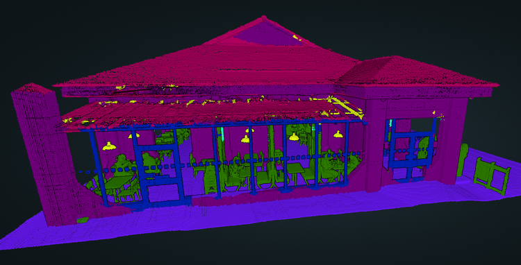
Vercator classification can greatly enhance asset management for offices by complementing and supporting the digital twin of the space created in NavVis IVION. The NavVis VLX captures a comprehensive 3D representation of the environment, including furniture, structures, and fixtures. Vercator’s smart machine learning algorithms can then classify each point in the cloud, identifying individual assets and their locations, separating the mass of data into ordered classes.
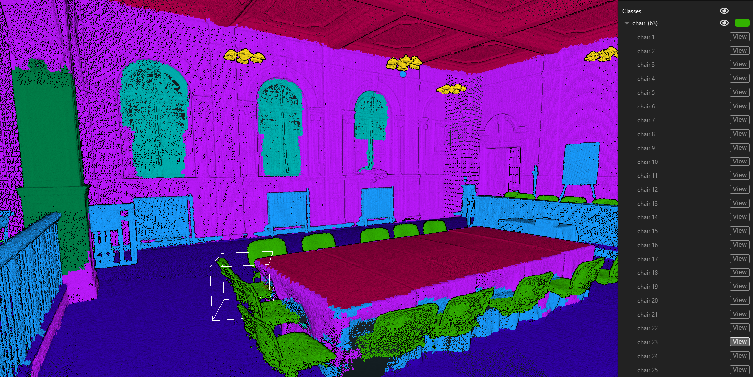
NavVis VLX data classified with Vercator into building assets. View in our demo gallery here.
Taking this result back into NavVis IVION enables more automated inventory management, simplifies space planning for reconfigurations, and streamlines maintenance by allowing these separated objects to be tagged, e.g. specific assets requiring attention. Imagine instantly generating reports on furniture types and quantities, easily visualizing new desk layouts in the digital twin, or automatically scheduling maintenance based on their location. Vercator’s point cloud classification offers a powerful and efficient approach to augmenting your NavVis workflow for managing office assets.
3D Modelling
3D models are often a key part of creating a Digital Twin or similar model for managing an asset virtually. The NavVis VLX can easily capture large commercial and residential spaces quickly but then all that data can be tricky to manage in 3D modelling software for efficient drawing up.
The advantage of using Vercator classification for 3D modelling comes from its ability to split up the data into manageable relevant classes. This means that you can load in just the building elements required into 3D modelling software, such as Autodesk Revit, making it easier for modellers to concentrate on the elements of interest and remove noise.
NavVis VLX data classified with Vercator into structural elements. View in our demo gallery here.
This article presented the benefits of using Vercator and NavVis together to deliver on your specific project needs. If you require an understanding of the assets in an environment or want to streamline your 3D modelling workflow, then the choice is easy. The power of Vercator’s AI to crunch through large NavVis capture with fast, accurate results means that their combination is far greater than the sum of their parts.
Do you have a NavVis VLX and want to unlock the power of the captured data?
Let the experts at Vercator show you how.

