
Creating a quality site plan is crucial for an efficient and accurate scanning process. As scanning becomes more widespread, more people will need to be involved in the process. But there are many challenges that can impede an effective plan. These include:
- Restricted access to a lived-in building or working site
- Unforeseen time challenges – a hazardous or unsafe sites
- Matching and managing client expectations
To get the scans you need, you have to plan. Even if you are considering cloud-to-cloud targetless registration, you still need to figure out how many scans you need, and from where, to get sufficient scan coverage. In fact, error propagation (specifically within the context of targetless registration) makes planning out the number of scans critical.
Planning allows you to define the optimal set of scanning locations while satisfying the specific quality and accuracy requirements of that particular job. Your site plan will primarily deliver four outcomes:
- The number of scans to be done
- Whether colour scan data is required
- The difficulty of getting those scans done — for example, scans on-site with limited access or scans with restrictions and local traffic
- Idiosyncrasies of the site location
Conducting site planning is time-consuming. So, it’s vital that the site data be acquired in the most efficient way with the minimum number of scans possible. Here are a few guidelines to put you on the right path.
Step 1: Build in preparation time
Preparation is vital. Creating the right site plan is fundamental to any project where laser scanning/federated 3D modelling is concerned. Ensure that you have allocated sufficient time as part of your project’s site investigation stage for the right people to get on-site, set up the site plan and generate a site reference control grid if needed. Many stakeholders will be keen to “just get going” and managing this expectation early in the project will pay dividends later.
At this stage, also look at how you are capturing information. Avoid paper at all costs. Use mobile apps to capture where you should be placing your scanners on-site. You can easily record your scanning and target locations as you move through a scene, and upload a tablet- generated map to ensure accuracy when plotting your scanning points. 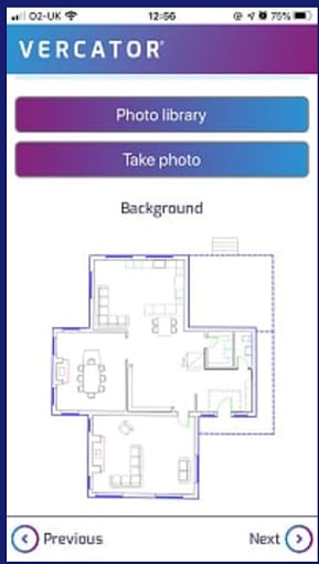
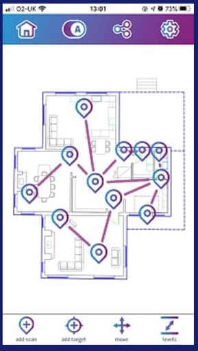
While you may have lined up surveyors to go on-site and carry out the 3D scans, you also have to ensure you have people allocated to do the site planning. Your people will need to have experience using the equipment you have chosen. For example, creating site survey control points (using a total station) may require different skills and equipment than the 3D laser scanning. They will also need to plan the order in which you are going to scan the site.
Step 2: Select the right scanner
The need to scan complex and sometimes inaccessible sites is often critical to support your project requirements. While companies increasingly consider high-speed 3D laser scanning to be the go-to piece of surveying technology, it’s not the only tool for this purpose. Easy-to-use and highly portable terrestrial laser scanning systems that operate at the touch of a button can provide a simple way to capture site data.
Consider the application of:
- Static laser scanners: These are traditional 3D laser scanners able to deliver high levels of precision using both target-based and targetless registration methods.
- GNSS-enabled scanner: These are mobile scanning devices that pull on a number of sensor inputs (including GNSS location data) to deliver rapid mobile scanning outdoors.
- IMMS: Indoor Mobile Mapping Systems deliver mobile scanning outcomes where GNSS signal is not present (specifically indoors). These use a number of techniques, predominantly SLAM (Simultaneous Localisation and Mapping). These are fast and flexible, but often lack the precision of static laser scanners.
Suggested reading: To learn more about scanner types, check out our blog — 3 Types of Terrestrial Laser Scanners.
Mobile mapping systems can provide scan data for large-scale environments. Unmanned aerial systems (UAS, also known as drones or UAVs) provide a way to capture scene perspectives and provide access where physical entry may be restricted. And cloud-based software solutions can streamline efforts by turning digital data into accessible visualisations and intelligent diagrams and maps.
You also should also consider the value of combining multiple scanner types to deliver optimal scene coverage while also optimising the efficiency of scanning. However, to do this, you need to make sure that you have the software capabilities to integrate different scan types and layer scans where most appropriate.
Suggested reading: If you want to learn more about mobile scanning, and how to integrate multiple scan types together, check out our free ebook — How SLAM Enables the Evolution of Wearable Reality Capture Technology.
Step 3: Optimise the number of scans by creating a scan route
Laser scanners make line-of-site measurements. So, a room with lots of pillars, small hallways, and other hard to cover obstacles will require far more scans to cover than a larger, but empty room.
You also have to consider things like how much detail you need and what you want to do with the scans. Nothing beats a site walk, but a set of 2D plans and photos can also do the job. Particularly if you are using static scanners, you need to take scan route planning seriously.
Your first goal in planning a scan route should be to make sure that you gain total scene coverage. You also want to try and be efficient in the number of scans you take. Fundamentally, if you are able to take fewer scans to get complete coverage, the entire process will be more efficient and minimise propagation errors.
Minimise errors and rework
Combining 3D laser scans introduces errors. Propagation errors, as they are known, are inherent scanner limitations which compounded as scans are combined. A critical step in site planning is deciding whether or not the total number of scans will create more propagation error than the accuracy parameters of the job-specs can handle.
For a composite point cloud, scans are effectively built on top of each other, all rooting back to a single ‘home’ scan. The more ‘steps’ between any given scan and its ‘home’ scan, the greater propagation error it will suffer. They can be minimised by good site planning but can never be removed.
Uncertainty grows based on the following equation: (n1*2)2 + (n2*2)2 … = (total error) [where ‘n’ is the error rate for each scan].
So, if you have a scan error of +/- 1mm, that will compound to +/- 4mm for every scan one-removed from the ’home scan’. If that error propagation number exceeds the parameters for the project — you will need to build a site grid, also known as a set of ‘survey control points’ or ‘control network’.
A site grid is a set of fixed targets throughout a scene, each with a known relative location measured with precision using a total station. Total stations are capable of achieving measurements an entire order of magnitude more precise than 3D laser scanners. By completing your site plan and capturing survey control points, you can match your control points to the point cloud during the registration process. If needed, this is a critical step in the process of creating an accurate point cloud — regardless of whether or not you are going to use targets to register the 3D laser scans.
By being judicious in the number of scans you create, you can potentially remove the need to make a site grid at all. Depending on the type of project you are undertaking you may choose to not install a site grid. However, you will need to ensure that you get the accuracy you need for your project. It’s never worth cutting corners if it compromises the outcome, use and validity of the resulting point cloud.
Step 4: Review processes to speed implementation
One of the biggest savings in using the latest generation of laser scanners and registration software is time. In the field, targetless scanning saves time by avoiding target placement and enables larger projects to be scanned more quickly.
Not all point cloud registration software easily integrates the reference site plan survey control points with those generated by the point cloud. If your registration software is up to it, scans that pick up your existing control targets can be placed within a control frame with as close to the level of precision that they possess themselves. You will also need less overlap between scans and therefore need fewer scans to be taken in the field.
You can lose that time advantage later in the workflow if you are carrying poor cloud-to-cloud alignment, or if you don’t have the processes and workflows in place to provide end-to-end benefits.
It is especially worth looking out for software that can take advantage of cloud-based, multi-thread, simultaneous processing throughout the entire processing procedure. This can result in orders of magnitude processing speed increases.
Vercator uses cloud-based multi-stage vector analysis to deliver faster, automated and more robust results. Here, the positional data of the scanner is used to map each point into a directional vector. This allows entire scans to be collapsed into single points, creating ‘vector spheres’. The density and directional characteristics of the vectors retain the unique identity of the point clouds.
The impact of good site planning
3D scanning is trusted for its accuracy, reliability, speed, and ease of use. The adaptability and exceptional flexibility of 3D scanning make it ideal for measuring in a wide range of situations. That trust has to be maintained by ensuring good planning and preparation.
Good commercial sense means keeping site visits and the use of onsite devices to a minimum. By creating accurate site plans and associated control points, any cost in site planning is more than met by facilitating targetless scanning and optimising high-quality point cloud registration and processing further down the line. 
Tags: laser scanner, surveying, surveyors
